

Temperatures trend upward, breaking records and setting the stage for rain this weekend
New records will likely be set on Christmas Eve with temperatures in the 40s and 50s

Go Deeper.
Create an account or log in to save stories.
Like this?
Thanks for liking this story! We have added it to a list of your favorite stories.
Temperatures will be mild and continue their upward trend. Record highs are still likely for Christmas Eve with rain developing into Christmas Day.
Abnormal warmth continues and increases
Anomalous warmth continues with highs closing in on 40 degrees again Wednesday for southern Minnesota with sunshine. Northern Minnesota will see more clouds and even a few flurries on the Iron Range with temperatures closer to 30 degrees.

Overnight temperatures will mostly fall into the 20s to near 30 degrees, which are closer to, but still above normal highs even for the time of year. Thursday will be a couple degrees warmer with increasing clouds.
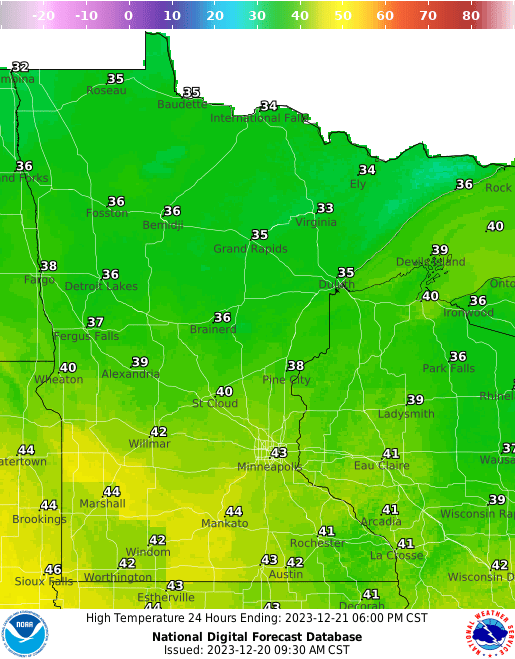
The warmest day ahead continues to look like Christmas Eve with highs in the 50s across southern Minnesota and 40s all the way to the international border. I’ve added an asterisk to likely records that will be broken for the date.
Turn Up Your Support
MPR News helps you turn down the noise and build shared understanding. Turn up your support for this public resource and keep trusted journalism accessible to all.

A wet Christmas vs. a white Christmas
A relatively minor disturbance will bring a few sprinkles south and flurries or possibly mixed precipitation to northern Minnesota on Friday.
The main event is a larger storm system that will develop widespread rain Christmas Eve into Christmas Day, potentially lingering into Tuesday of next week. Some of that moisture will turn to snow in northwest Minnesota Sunday night into Monday and we could even see a narrow swath of snowfall develop farther south Monday night into Tuesday, though models differ on the extent of that and placement.

We still stand to see significant precipitation. A quarter to as much as an inch of liquid-equivalent precipitation is possible into early Wednesday across the state. Most of that will fall as rain.

As mentioned, the models do hint at some snow, but there remains a question as to how much and where. We may run out of moisture and time by the time the cold air arrives.

Beyond the storm system and early next week, there’s no end in sight to the above normal temperatures. It will likely be cooler than the 40s and 50 degree temperatures, but still at least 10 degrees above normal.

