
Hovland got 38.6 inches of snow but fell short of Minnesota's all-time record
Climate experts weigh in on this week's prolific snowfall totals

Go Deeper.
Create an account or log in to save stories.
Like this?
Thanks for liking this story! We have added it to a list of your favorite stories.


It just kept coming.
Wednesday’s North Shore blizzard dumped prolific snowfall totals between 1 and 2 feet along much of the North Shore. Hovland, Minn., a few miles east of Grand Marais, was the epicenter.
Hovland’s astounding two-day storm snowfall total of 38.6 inches is one of the top single storm snowfall totals on record for Minnesota, although it’s well short of the all-time single storm snowfall record of 46.5 inches that fell at Wolf Ridge Environmental Learning Center near Finland, Minn., in January 1994.
It does look like the 24-hour snowfall total of 26.6 inches in Hovland Wednesday set a new February record for 24-hour snowfall in Minnesota. So this was definitely a tip-top-tier snowfall event.
Turn Up Your Support
MPR News helps you turn down the noise and build shared understanding. Turn up your support for this public resource and keep trusted journalism accessible to all.
Crunching the numbers
The observer in Hovland is very reliable, historically, so the snow total is likely accurate.
I reached out Thursday to longtime MPR News climate expert Mark Seeley as well as Kenny Blumenfeld of the Minnesota State Climatology Office. Kenny and Mark point out that while the 38.6 inches in Hovland was huge for Minnesota, amazingly it doesn’t set any all-time state snowfall records.
Like a lot of things weather, records can be complicated. Here’s part of my communication with Blumenfeld that explains how this storm fits well:
Hi Paul, we posted about this on Facebook and also contacted NWS Duluth and have had a great exchange with them. The snowfall has been amazing, and I have no reason to doubt that over three feet has fallen on some areas. We very much trust the official report from the Hovland observer in question. However, please spread the word that as of now, no (all-time) records have been broken. This is because of the amounts reported, the periods for which they were reported, how events get evaluated, and also because of standards used for establishing statewide climatic extremes.
As for the amounts, at Hovland, where 38.6 inches were recorded over two observation days (so far), the two daily/24-hour totals reported were 12 inches and 26.6. Neither breaks the official 24-hour record of 36.0 inches at the Wolf Ridge Environmental Learning Center on January 7, 1994 . Even if it was claimed that over 36 inches fell in *some* 24-hour period, that would be difficult to verify because daily observers are not asked to make sub-daily observations, and if observers had made such measurements, the extremes committee would need to understand how that was done. The storm total (as of this morning) did not exceed the record of 46.5 inches (from the same system, Jan 6-8, 1994 at Wolf Ridge).
Moreover, even though the Hovland observer has been an excellent observer over the past 10 years, currently CoCoRaHS observations are not considered for statewide records without a special exception by the statewide extremes committee. In fact, all records reported here require agreement by that committee, and often prompt a site visit to inspect the equipment and measuring environment. So even if the value appeared to qualify, more work would be required to verify it. The current practice is that only NWS Cooperative stations (and the five first-order airport stations) may qualify for temperature, precipitation, and snowfall records—though the committee may make exceptions.
For now, this second point about qualifying observer networks is moot because the values recorded do not break the records anyway. It’s possible someone at the National Weather Service or in the Climatology Office will push for this event to be reconsidered, but we’re pretty deep into our volley with them and the strong consensus is that as of now the current records stand.
I hope this helps, Paul, and thanks for getting the word out! Still an amazing storm!
Kenny
Seeley points out that this storm is only the 10th time in Minnesota history that a location has recorded more than 25 inches of snow in a 24-hour period.
Here’s a preview from his climate chat that you can hear on Morning Edition Fridays on MPR News:
MPR listener question:
We were amazed to see the 26.6 inches of snow reported from Hovland along the north shore this morning (Thursday). With the remarkable snowfall amounts coming from northeastern Minnesota, along Lake Superior, this week, we were wondering how many times has a daily snowfall of 25 inches or greater been measured in Minnesota?
Answer:
By my count an observer in Minnesota has reported 25 inches of snow or greater over a daily period only 10 times in history, including the February 19th report this week from Hovland. Of the 10 reports of daily snowfalls of 25 inches or greater, the largest is 36 inches at Wolf Ridge Environmental Learning Center in Lake County which occurred on January 7 of 1994. In fact, 6 of these 10 historically large daily snowfalls have occurred along the north shore counties of Minnesota. These include locations like Wolf Ridge, Isabella, Hovland, and Pigeon River. There has been one of these big storms in the Red River Valley (Kittson County in 1966), one near Mille Lacs in central Minnesota (1991), and one in southern Minnesota at St James (Watonwan County) in 1943. All were slow moving storm systems.
Thanks, Mark and Kenny!
Upslope and lake-enhanced snowfall rates
So why do we see such big snowfall rates of 2 to 3 inches per hour along the North Shore? Highs winds blasting off Lake Superior inject additional moisture into storm systems. That’s called lake-enhanced snow.
Those same winds slam into the ridges above the north sores and quickly rise up to 1,000 feet. That upslope orographic process cools and saturates the air even more quickly, wringing out even more snow.
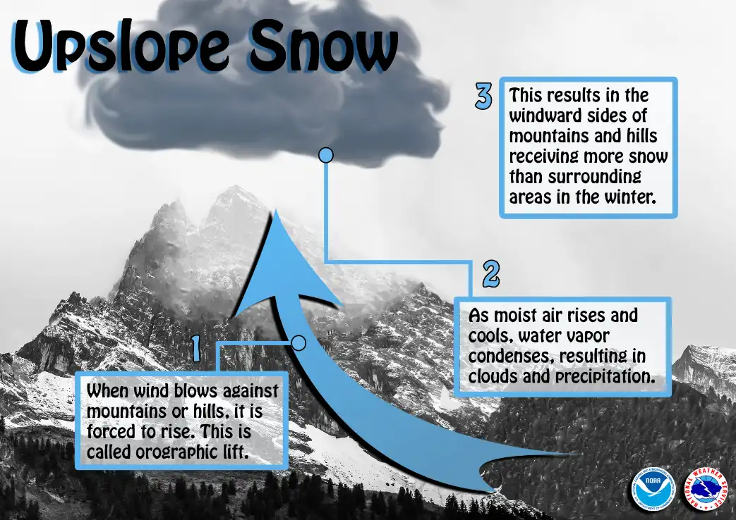
Meteorologist Mandy Thalhuber, my MPR News colleague, wrote a nice piece about upslope snow here.
Next storm Friday
The next Upper Midwest storm passes mostly south and east of Minnesota Friday — with one exception. It looks like this will clip far southeastern Minnesota and the North Shore once again with accumulating snow.
The National Oceanic and Atmospheric Administration’s FV3 model shows the storm’s snow bands favoring Iowa and Wisconsin. The forecast model loop below runs between 6 p.m. Thursday and 6 p.m. Friday.
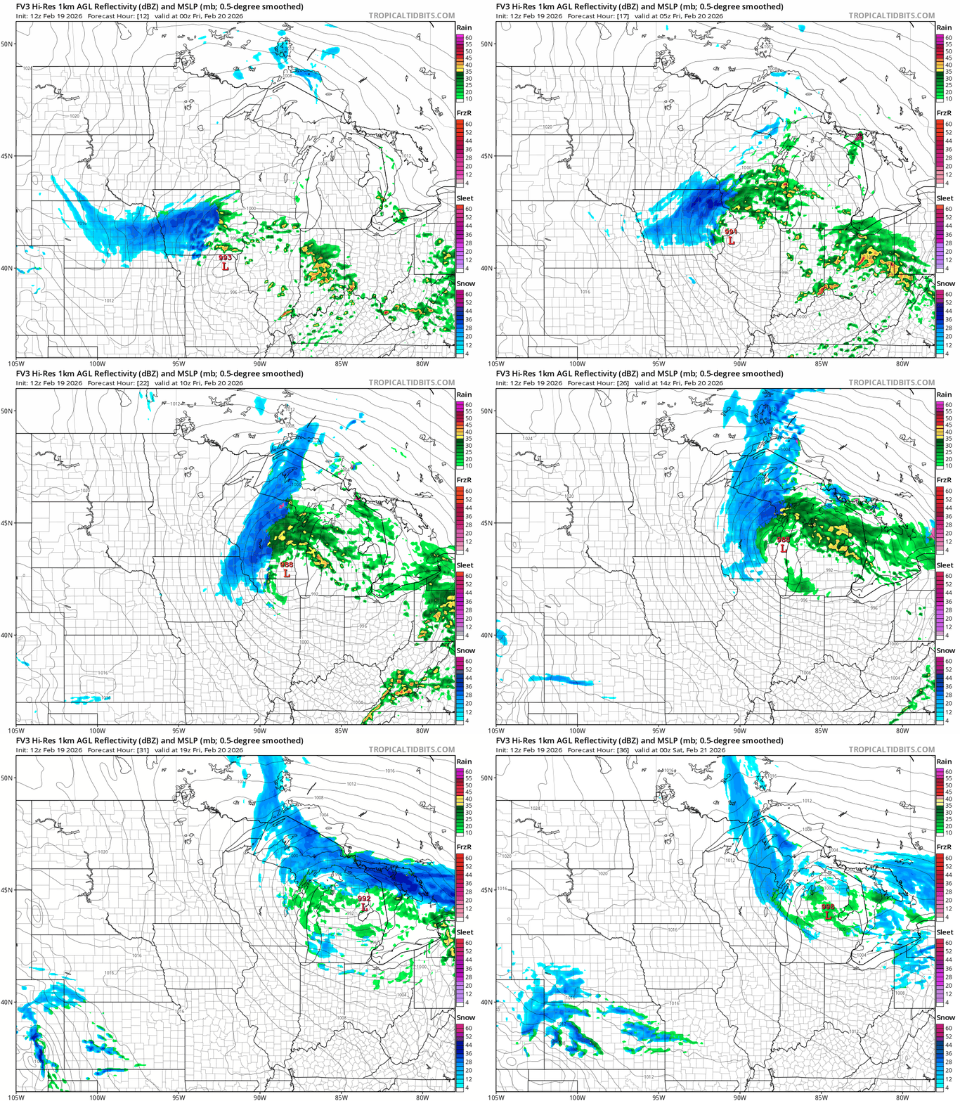
People traveling through Iowa should expect significant snow with this system.

The weekend looks quiet with winterlike temperatures.


