Messy weather week ahead for much of Minnesota
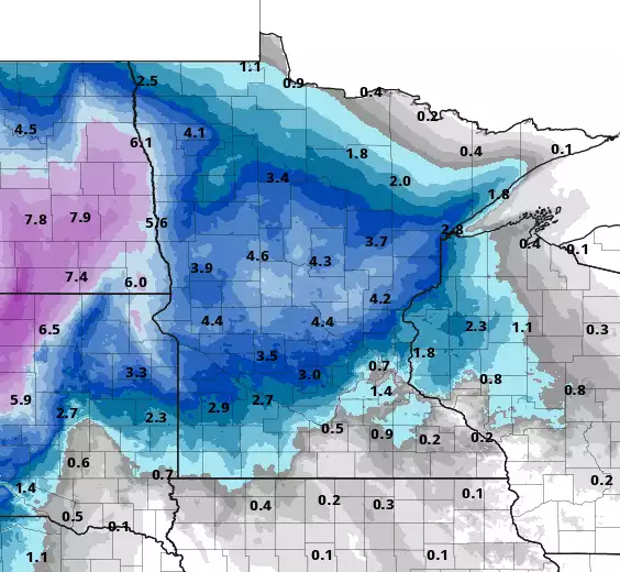
Forecast snowfall through 6 a.m. Wednesday (additional snow will fall Wednesday into the weekend, especially in northeast Minnesota.)
NOAA via Pivotal Weather
Go Deeper.
Create an account or log in to save stories.
Like this?
Thanks for liking this story! We have added it to a list of your favorite stories.
Audio transcript
[MUSIC PLAYING] CATHY WURZER: As I mentioned, the weather this week will be a mess. You are forewarned. While much of Northern and Western Minnesota face winter storm watches, the metro area and Point South will see some rain and ice. To fill us in on the details, meteorologist, Sven Sungaard, is on the line. Hey, Sven.
SVEN SUNGAARD: Hi, Cathy. Yeah, we've got a slow moving mess, really, for much of the week coming up.
CATHY WURZER: Is this the same system that produced this dumped snow in the Sierra Nevada over the weekend? What, they had 4 to 5 feet of snow measured in the Tahoe region?
SVEN SUNGAARD: Yeah. This won't do that for us though, luckily. But we could be measuring-- we could be measuring the snow in feet along the North Shore. That looks to be the place that's going to win the most snowfall out of this whole system.
But it is going to be, really, a wintry mess. And this is what we call an upper level low. So it's a strong core of cold air aloft. And it's cut off from the main flow of the atmosphere. So it's a cutoff low. That's why it's going to move so slow.
And yeah, it's just been progressing across the West. And the center of it is still over the Rocky Mountains right now. And out ahead of it, we're seeing this surge of moisture start to fill in. So today is the dry day, the calm before the storm, if you will.
CATHY WURZER: OK, so go out and enjoy and get your shopping done or whatever because it's going to be a bit of a mess. So what happens then, starting tomorrow morning, perhaps?
SVEN SUNGAARD: Yeah, so today, first, we've got some fog in southwestern Minnesota. It's in the upper 20s there. Warmer, though, East. We're above freezing. 33 in the Twin Cities.
Breezy out of the Southeast. And dry through the day today. But tonight, we're going to see precipitation develop in southwestern Minnesota, a mixture of snow and freezing rain. Temperatures are going to be just in that wrong spot where it'll be upper 20s at the surface, places like Pipestone, Worthington, Windham.
But you go aloft and we see that warm air move up and over the cold air being drawn into this storm system. So it will actually be above freezing. So liquid precip that becomes super cooled, which means it's below freezing, but still in liquid form, and then freezes on contact. So when it hits those telephone poles or tree branches that are 28 degrees, you get that ice accumulation to develop.
So this could be a potential issue for downed power lines, power outages in the southwestern part of state. So between about 2:00 and 6:00 AM tomorrow is looking like the best potential for ice. Some spots could see a tenth of an inch to maybe a few tenths of an inch of ice accumulation. And then, of course, strong winds develop tomorrow, which will help to break off some of those branches or anything that's weighted down by some of that ice accumulation.
CATHY WURZER: Oh, shoot. So we're talking about Pipestone, Windham, those areas, right?
SVEN SUNGAARD: Yeah, that's where-- those look to be the areas best poised for that potential for ice. And yeah, that's a bad-- Saint James, maybe even up as close as New Ulm could see some of that in the early morning hours.
CATHY WURZER: Oh, ice. Not good. OK, so--
SVEN SUNGAARD: The worst.
CATHY WURZER: Yeah, no kidding. So then that's tomorrow morning. So what is the rest of the storm looking like then, into tomorrow?
SVEN SUNGAARD: So that mixture of precip will slowly move North and East through the day. So by already lunchtime, we might start to see a few rain and snow showers in the Twin Cities, in southeastern Minnesota. It looks like it's going to be a progression through the afternoon.
So it's going to be like a light switch and all of a sudden the moisture is on. It's probably going to start in spits and thrusts here through the afternoon. And so by the mid to late afternoon, it looks like we'll start to see a steadier rain/snow mix.
But again, temperatures in the Twin Cities and much of southeastern Minnesota will be just above freezing, so probably just wet. But you're going to see everything falling from the sky. Central Minnesota, though, probably cold enough, just on the cold side of this system to see mainly snow, especially into tomorrow night. And that's when the accumulations develop.
So what we see in the Twin Cities will probably be less than an inch of slush. But as close as Saint Cloud could see 3, 4, 5 inches. Brainerd, Fergus Falls, Morris, over towards Mora. And then North and South of that swath will be a little bit less. So 1 to 3 inches around Bemidji and Duluth and then Montevideo and Wilmer.
CATHY WURZER: And delightful that we'll have heavy winds too, high winds.
SVEN SUNGAARD: Yeah, wind gusts tomorrow up to 40 miles an hour. And that wind is probably going to be with us into Thursday until we get rid of this system. So then during the day Wednesday, we get into the dry slot of this storm, it looks like, across Southern Minnesota, including the Twin Cities. So that means we'll be mainly dry. Most of the moisture will lift North.
This is when the snow machine really gets going along the North Shore. Moose Lake, Duluth, and then up the shore snow all through the day Wednesday into Wednesday night and Thursday. Heavy at times, you'll get that lake enhancement. The wind is going to be perfectly poised off of Lake Superior, so we're talking a foot.
There are going to be some spots that, I think, that are going to get, possibly, two feet of snow along the higher terrain in the North shore. The typical culprits, you know, Isabella, Finland, some of those spots.
CATHY WURZER: Oh, great. OK, so, but wait, there's more.
SVEN SUNGAARD: But wait.
CATHY WURZER: It keeps going.
SVEN SUNGAARD: That's why I really want to tell people, enjoy the dry day today because it's going to be a while before we have a fully dry day again.
CATHY WURZER: Great. OK. So you got to-- let me see now. We got to Wednesday in the North Shore--
SVEN SUNGAARD: We're up to Thursday now.
CATHY WURZER: OK, go ahead. Yeah.
SVEN SUNGAARD: I know. We got to kind take it day by day in phases. So finally, by Thursday, it's cold enough across Minnesota that whatever we see will be in the form of snow. And it's not going to be steady. But there will be bands of snow wrapping around the center of the system.
And this is when we could see maybe the snow finally accumulate more in the Twin Cities, maybe a couple of inches Thursday into Friday. It will continue along the North shore. But we're going to see snow showers probably right into Saturday.
So Twin Cities totals, that's a little far out to see. But we're going to see the least of this. So that's why we're not included in the winter storm watch.
That's basically all of Western Minnesota and then North, Central Minnesota, up the North shore. So places like Montevideo, Worthington, Saint Cloud, Brainerd, Duluth, up to Grand Portage in the winter storm watch. We are not in that watch.
CATHY WURZER: Could that change, though?
SVEN SUNGAARD: It could change. So this is going to be a really tricky situation day by day, depending upon when we can switch over to the snow. Will there be a lot of moisture left over by Thursday, Friday? That's one of the question marks.
And you know, especially tomorrow, do we see slower turn over to a mixture of rain and snow? Or do we just stay on the warm side and see a lot of rain in southeastern Minnesota tomorrow? That will be-- those will be some of the key questions.
CATHY WURZER: OK. So then I am assuming-- this is such a large storm system that behind it must be pretty decently cold weather.
SVEN SUNGAARD: Yeah, because it's such a slow moving low, it literally is going to act like kind of a vacuum over North America. And you know what's going to fill it. It's not going to be warm tropical air. Cold air is coming in from the North.
And it's going to be slowly marching across Canada through the week. So by the time we head in the weekend, temperatures will drop into the 20s for highs on Saturday, teens in Northern Minnesota. Teens, pretty much statewide Sunday.
And then next week, it looks like the coldest air of the season so far, potentially. We're talking about temperatures that could be 20 degrees below normal or more, possibly our first zero overnight lows in the Twin Cities. We have not gotten below zero yet. 4 is the coldest we've been.
I know you've been looking forward to that day. And it looks like that could finally happen next week. We're talking about teens below in northern Minnesota, and probably some wind at that too. So some pretty brutal windchills again next week.
So you know the drill. Pretty much after any storm, we get some cold. But a bigger storm draws in even bigger cold. But I think you'll be welcoming the sun because it's going to take that cold air to get some sunshine next week. It's going to get pretty gloomy here. We're talking about several days in a row of pretty gray skies.
CATHY WURZER: And how would you say our listeners should prepare for this storm?
SVEN SUNGAARD: You know, you kind of have to take it region by region. The biggest concern these next 24 hours is southwestern Minnesota. We talked about the ice. So really pay attention to that. And as mentioned, get any errands done or stock up on groceries because ice is literally the worst thing.
And then northern Minnesota's when the snow really gets going-- Central and Northern Minnesota tomorrow night into Wednesday. So watch out for heavy snow there. Twin Cities, we may fare a little bit better here until we really head into Thursday and see more of that steadier snow start up here and in southeastern Minnesota.
CATHY WURZER: OK. Of course, we will take it day by day. We'll keep following you and the rest of the weather team and check out the Updraft blog. I hope you have a good afternoon.
SVEN SUNGAARD: Yeah, much more is there. You too, Cathy.
CATHY WURZER: Thanks, Sven. Sven Sungaard, one of our meteorologists. He mentioned Updraft. That's the blog. Where do you find it? nprnews.org.
Download transcript (PDF)
Transcription services provided by 3Play Media.
