

Nowcast: Strong to Severe storms just south and east of metro through evening

Go Deeper.
Create an account or log in to save stories.
Like this?
Thanks for liking this story! We have added it to a list of your favorite stories.
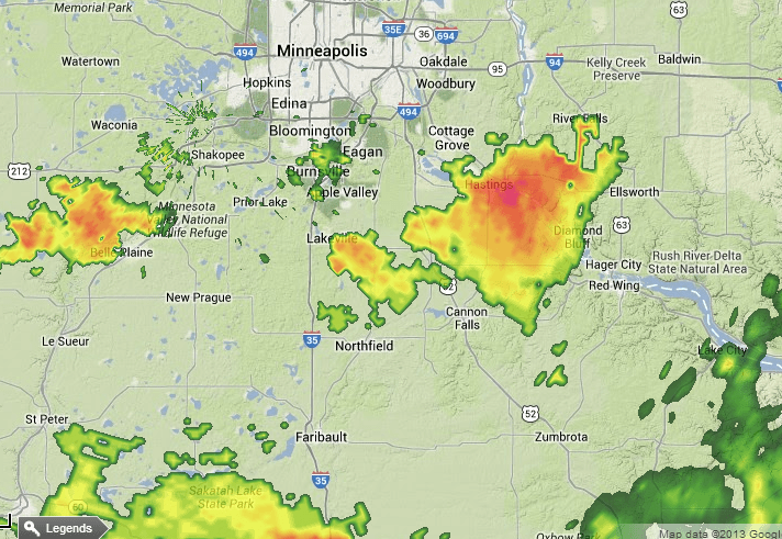
"Hailers:" Most of the storms will develop south and east of the greater Twin Cities metro tonight. The biggest threats are large hail and damaging winds. Here are some early hail reports from NWS spotters.
MPX: 1 N NEW Prague [Scott Co, MN] trained spotter reports HAIL of penny size (M0.75 INCH) at 03:18 PM CDT
MPX: Lakeville [Dakota Co, MN] public reports HAIL of quarter size (M1.00 INCH) at 03:25 PM CDT -- at county road 50 and ipava ave
MPX: Hastings [Dakota Co, MN] public reports HAIL of quarter size (M1.00 INCH) at 04:10 PM CDT -- time estimated
MPX: Hastings [Dakota Co, MN] public reports HAIL of ping pong ball size (M1.50 INCH) at 04:07 PM CDT --
NOAA's SPC has issued a Severe Thunderstorm Watch for areas east of the Twin Cities until 11pm tonight.

Turn Up Your Support
MPR News helps you turn down the noise and build shared understanding. Turn up your support for this public resource and keep trusted journalism accessible to all.
Dear reader,
Your voice matters. And we want to hear it.
Will you help shape the future of Minnesota Public Radio by taking our short Listener Survey?
It only takes a few minutes, and your input helps us serve you better—whether it’s news, culture, or the conversations that matter most to Minnesotans.
