Arctic weekend; Have we ever stayed above zero all winter?
Go Deeper.
Create an account or log in to save stories.
Like this?
Thanks for liking this story! We have added it to a list of your favorite stories.
Better late than never?
The Twin Cities and most of Minnesota should finally plunge below zero this weekend. The onset of sub-zero temps are a full month later than average this winter. A few of you have asked me, have we ever had a winter without sub-zero temps in the metro? I'm pleased(?) to report the answer is no. Temperatures have dipped below zero at least twice every winter season in the Twin Cities.
A Minnesota weather merit badge of honor?
[image]
Turn Up Your Support
MPR News helps you turn down the noise and build shared understanding. Turn up your support for this public resource and keep trusted journalism accessible to all.
Purple pain
Blue on the weather maps means cold. Purple? Pure polar pain. This NOAA 4 km resolution NAM model loop below captures the essence of the season's first true Arctic air mass pouring south.

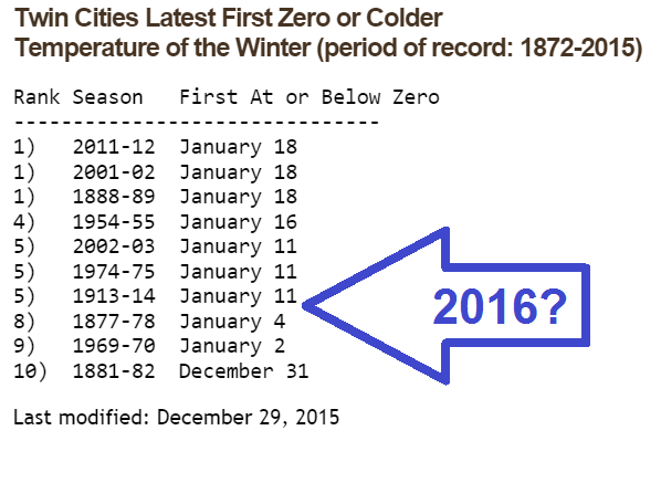
8th latest sub-zero start to winter
The long-term average date for season's first sub-zero temp at MSP is December 8. And yes weather fans, temperatures have always dipped below the zero mark at least twice every winter in the Twin Cities in 143 years of records. Last winter we hit -4 at MSP on Nov. 27.
Temperatures at the airport will dip below zero late Saturday night or early Sunday. That makes this the 8th latest sub-zero start to winter on record in the Twin Cities.

More perspective on our late sub-zero start this winter in the Twin Cities from the Minnesota DNR Climate Working Group.
So far at the Twin Cities there has not been a minimum temperature of zero or colder for the winter of 2015-16. How rare is it to go so late in the season without a minimum of zero or colder?
In 143 years of record keeping in the Twin Cities, the official temperature has always fallen below zero sometime during the winter. There has never been a Twin Cities winter where the temperature has not dipped to zero or colder at least twice.
The long term average for the first below-zero reading in the Twin Cities is December 8. The earliest below-zero temperature recorded in the Twin Cities was November 4, 1991.
Arctic high pressure cell
We define air masses in meteorology by the source region they form in, and the properties of the air they hold.

That big blue 'H' on the weather map diving down from Canada over the Midwest this weekend? That's what we call a continental Arctic (cA) air mass. Yukon cold. Arctic desert dry. A static spark alert on doorknobs is in effect this weekend.

By Sunday morning you'll believe you live in Minnesota once again as temps and wind chills plummet well below zero across the Upper Midwest.

Tundra Bowl tracker
New day, same forecast. It's going to be (insert adjective here) cold at the Vikings playoff game Sunday. If kickoff temp is +2 degrees or colder, we'll crack the top 10 coldest NFL games on record.
Here's a look at probable game time temps from NOAA's digital forecast database.

Actual numbers could vary by a few degrees Sunday, but with temps hovering a few degrees either side of zero and chills near -20 it's going to be dangerously cold. If you're going to the game your seat location will also affect your micro-climate. My seat? About 10 feet from the large flat screen TV in a 68 degree family room.

Properly winterized next week
We bounce around a few degrees either side of zero from Sunday through next Wednesday. Temperatures moderate back to near seasonal average in the 20s by late next week. No major snow systems on the horizon for now.

Stay warm and classy Minnesota.


