Moderate risk: Unprecedented December severe weather outbreak likely late Wednesday

Highs wind warnings Wednesday. Severe 75 mph wind gusts and tornadoes possible.
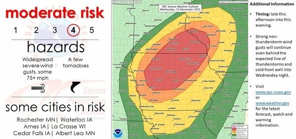
Severe weather risk areas Wednesday
Severe weather risk areas Wednesday.
NOAA

A short but important severe weather update for you night owls or early risers Wednesday.

The National Oceanic and Atmospheric Administration Storm Prediction Center’s midnight update has elevated the severe risk across much of southern Minnesota, Iowa, and western Wisconsin to the second highest of the five weather severe risk categories.

A moderate risk for severe storms now covers most of southeast Minnesota, northern Iowa, and part of western Wisconsin. An ehanced risk zone now covers the southeast Twin Cities, including Scott, Dakota, and southern Washington counties. A slight risk includes most of the Twin Cities including downtown Minneapolis and St. Paul.

Severe weather risk areas
Severe weather risk areas.
NOAA/IEMBot

Highest threat window: Late afternoon and evening

The highest threat for severe storms favors the late afternoon and evening hours as the system blows warmer, unstable air with temperatures in the 60s into southern Minnesota.

Create a More Connected Minnesota

MPR News is your trusted resource for the news you need. With your support, MPR News brings accessible, courageous journalism and authentic conversation to everyone - free of paywalls and barriers. Your gift makes a difference.

High temperature (51 degrees) and dew point (49 degrees) records for Dec. 15 could be broken in the Twin Cities and across southern Minnesota.

NOAA’s GFS model pushes temperatures to 60 degrees in the far southner Twin Cities.

NOAA GFS temperature forecast for 6 pm Wednesday
NOAA GFS temperature forecast for 6 pm Wednesday.
NOAA via pivotal weather

‘Exceptional wind fields’

The forecast wind field late Wednesday at about 18,000 feet above ground is about 150 mph. And it’s 80 mph just 5,000 feet above ground level. Severe thunderstorms can tap those winds and drive wind gusts in excess of 75 mph to ground level.

NOAA’s convective outlook discussion highlights the exceptional nature of forecast wind fields at various levels of the atmosphere above ground.

The overall intensity of the wind fields with this system are very impressive. Consensus among the guidance is that 500 mb wind speeds will top 130 kt, with 700 mb and 850 mb flow topping 95 kt and 70 kt respectively.

The expected result is a strongly forced, relatively narrow line of thunderstorms, likely beginning over far eastern NE during the late afternoon/early evening before quickly moving northeastward across IA, southern MN, and much of WI. Given exceptional wind fields, storm motion over 70 kt is possible and significant wind gusts appear likely with any persistent deep convection. These significant severe wind gusts represent the primary hazard, but enough curvature exist within the low-level wind profile for embedded QLCS tornadoes.

Tornado threat

Tornado paramaters in weather maps suggest potential for both supercell and QLCS (squall line) tornadoes. QLCS tornadoes are associated with squall lines during severe thunderstorms outbreaks. Either type of tornado can produce winds over 100 mph and locaized severe damage.

High wind warning

The powerful storm’s tight pressure gradient will produce high winds even before potentially severe storms develop. Wind gusts to 60 mph are possible Wednesday afternoon across much of southern Minnesota.

Including the cities of Elk River, Monticello, Minneapolis, Blaine, St Paul, Stillwater, Granite Falls, Olivia, Hutchinson, Gaylord, Chanhassen, Chaska, Victoria, Shakopee, Hastings, Redwood Falls, New Ulm, St Peter, Le Sueur, Faribault, Red Wing, St James, Mankato, Waseca, Owatonna, Fairmont, Blue Earth, and Albert Lea

1217 AM CST Wed Dec 15 2021

...HIGH WIND WARNING REMAINS IN EFFECT FROM 3 PM THIS AFTERNOON TO 3 AM CST THURSDAY...

* WHAT...Southwest winds 25 to 35 mph with gusts up to 60 mph expected.

* WHERE...Portions of central, east central, south central, southeast, southwest and west central Minnesota.

* WHEN...From 3 PM this afternoon to 3 AM CST Thursday.

* IMPACTS...Damaging winds will blow down trees and power lines. Widespread power outages are expected. Travel will be difficult, especially for high profile vehicles.

* ADDITIONAL DETAILS...Widespread wind damage may also occur with a line of thunderstorms early this evening. Some wind gusts may exceed 80 mph.

Be prepared for widespread high winds, and likely severe weather watches and warnings Wednesday afternoon and evening.