Updraft® - Minnesota Weather News

Arctic cold continues through Sunday; updated wind chill warnings and advisories

Snow Saturday night from Iowa into Illinois and southern Wisconsin

John Brower
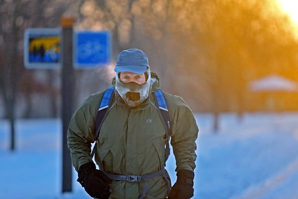
John Brower braves the frigid -20 weather to run to work at sunrise along West River Parkway, Monday, Jan. 6, 2014, in Minneapolis.
Elizabeth Flores | The Star Tribune via AP

How cold is it?

Saturday afternoon temps were in the teens below below zero in much of northwestern and west-central Minnesota.

Our official Twin Cities high temp this New Year’s Day happened at 12:35 a.m., when it was 1 degree above zero at MSP airport. The “warmest” Saturday afternoon temperature at MSP airport was 5 below zero. I saw a 1 below zero reading at Holman Field Airport in St. Paul.

Our average Twin Cities high temp is 25 degrees above zero on New Year’s Day. Our record coldest Twin Cities Jan. 1 high temp was minus 12 degrees, in 1974. The low was -30 that day.

Cold temps and wind chills

Lows Saturday night and early Sunday will reach the 20s below zero in many areas:

rt0102l4
Sunday forecast lows
National Weather Service

A few spots in northern and central Minnesota could drop below -30.

There will be enough wind to create wind chills of -35 and colder in many areas. A wind chill warning runs from Saturday evening through 10 a.m. Sunday in portions of the Twin Cities metro area and across much of Minnesota. The wind chill warning is shaded darker blue on the following map, with wind chill advisories in light blue:

rt0101mpx4
Wind chill warnings and advisories until 10 a.m. Sunday
National Weather Service

Here are details of the wind chill warning that includes portions of the metro area:

URGENT - WINTER WEATHER MESSAGE National Weather Service Twin Cities/Chanhassen MN 225 PM CST Sat Jan 1 2022 MNZ051>053-059-061-068-069-WIZ014-020430- /O.UPG.KMPX.WC.Y.0001.220102T0000Z-220102T1700Z/ /O.NEW.KMPX.WC.W.0001.220102T0000Z-220102T1600Z/ Sherburne-Isanti-Chisago-Wright-Anoka-Carver-Scott-Polk- Including the cities of Elk River, Cambridge, Center City, Monticello, Blaine, Chanhassen, Chaska, Victoria, Shakopee, and Osceola 225 PM CST Sat Jan 1 2022 ...WIND CHILL WARNING IN EFFECT FROM 6 PM THIS EVENING TO 10 AM CST SUNDAY... * WHAT...Dangerously cold wind chills expected. Wind chills as low as 40 below zero. * WHERE...Portions of northwest Wisconsin and central and east central Minnesota. * WHEN...From 6 PM this evening to 10 AM CST Sunday. * IMPACTS...The dangerously cold wind chills could cause frostbite on exposed skin in as little as 10 minutes. PRECAUTIONARY/PREPAREDNESS ACTIONS... Use caution while traveling outside. Wear appropriate clothing, a hat, and gloves.

Minneapolis and St. Paul are included in a wind chill advisory for wind chills as low as -35 Saturday night and early Sunday.

Northwestern Minnesota remains in a wind chill warning until 10 a.m. Sunday, for wind chills as low as -40 to -55:

rt0101gfk4
Wind chill warning until 10 a.m. Sunday
National Weather Service

Northeastern Minnesota has wind chill warnings and advisories that continue until noon on Sunday:

rt0101dlh4
Wind chill warnings and advisories until noon Sunday
National Weather Service

You can hear updated weather information for Minnesota and western Wisconsin on the Minnesota Public Radio News network, and you can see updated weather info on the MPR News live weather blog.

Snowstorm to the south

A weekend snowstorm continues this Saturday night in southern and central Iowa, plus portions of Illinois and southern Wisconsin.

The National Oceanic and Atmospheric Administration’s North American Mesoscale (NAM) forecast model shows the potential precipitation pattern from Saturday evening through Sunday morning:

rt101rad3
Simulated radar Saturday evening through Sunday morning
NOAA, via Tropicaltidbits.com

Here’s the NWS snow forecast for Iowa:

rt0101iasnow
Iowa snow forecast Saturday and Saturday evening
National Weather Service

Here are Wisconsin snow forecasts, with “tonight” referring to Saturday night:

rt0101wisno
Forecast snow amounts
National Weather Service

Here are Wisconsin winter storm warnings and winter weather advisories:

rt0101wiswrn
Saturday night warnings and advisories in southern Wisconsin
National Weather Service

Much of northern Illinois is in a winter storm warning until 6 a.m. Sunday:

rt0101ilwrn4
Winter storm warning northern Illinois until 6 a.m. Sunday
National Weather Service

Here are forecast details for the Chicago area:

URGENT - WINTER WEATHER MESSAGE National Weather Service Chicago IL 250 PM CST Sat Jan 1 2022 ILZ006-013-103>105-INZ001-002-020600- /O.CON.KLOT.WS.W.0005.000000T0000Z-220102T1200Z/ Lake IL-DuPage-Northern Cook-Central Cook-Southern Cook-Lake IN- Porter- Including the cities of Waukegan, Buffalo Grove, Mundelein, Gurnee, Naperville, Wheaton, Downers Grove, Lombard, Carol Stream, Evanston, Des Plaines, Schaumburg, Palatine, Northbrook, Chicago, Cicero, Oak Lawn, Oak Park, La Grange, Calumet City, Oak Forest, Lemont, Orland Park, Park Forest, Gary, Hammond, Merrillville, Portage, Valparaiso, and Chesterton 250 PM CST Sat Jan 1 2022 ...WINTER STORM WARNING REMAINS IN EFFECT UNTIL 6 AM CST SUNDAY... * WHAT...Snow, falling heavily at times, with developing blowing snow and dangerous travel expected. Total snow accumulations of 5 to 9 inches are expected with the highest amounts expected over northern Cook and Lake County, IL. Northeast winds could gust up to 40 mph this evening, especially near the lake. * WHERE...Portions of northwest Indiana and northeast Illinois. * WHEN...Until 6 AM CST Sunday. * IMPACTS...Travel could become very difficult. Blowing snow after sunset this evening could significantly reduce visibility, especially along the Lake Michigan shoreline. * ADDITIONAL DETAILS...The heaviest snow rates are expected through about midnight tonight. PRECAUTIONARY/PREPAREDNESS ACTIONS... If you must travel, keep an extra flashlight, food, and water in your vehicle in case of an emergency. The latest road conditions for Illinois can be obtained on the internet at www.gettingaroundillinois.com.

You can click on any location here for the latest warnings and advisories.

Severe weather outlook

There is an enhanced risk of severe weather in several southern states Saturday evening and overnight.

As of 5 p.m. Saturday, the NWS Storm Prediction Center had issued tornado watches from northern Louisiana to southeastern Kentucky:

rt0101mpx5
Tornado watches (red) in effect at 5 p.m. Saturday Jan.1, 2022
NWS Storm Prediction Center

Temperature trends

Sunday highs will creep slightly above zero in many areas, with teens in parts of southwestern Minnesota:

rt0102h4
Sunday forecast highs
National Weather Service

Temps recover nicely on Monday, with highs in the 20s in many locations and a few lower 30s in southwestern Minnesota:

rt0103h4
Monday forecast highs
National Weather Service

Twin Cities metro area highs are projected to reach about 30 on Tuesday. Our highs then retreat to the lower teens on Wednesday, followed by single-digit highs Thursday and Friday.

Programming note

You can hear my live weather updates on MPR News at 7:35 a.m., 9:35 a.m. and 4:39 p.m. each Saturday and Sunday.

Volume Button
Volume
Now Listening To Livestream
MPR News logo
On Air
MPR News with Angela Davis