Tornado watch south of Twin Cities; severe thunderstorm watch for metro area

Tornadoes, large hail, damaging winds all possible across southern Minnesota

Tornado watch
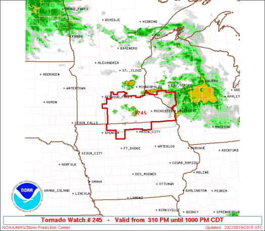
Tornado watch until 10 p.m.
National Oceanic and Atmospheric Administration

Updated 5 p.m.

The National Oceanic and Atmospheric Administration Storm Prediction Center has issued a tornado watch until 10 p.m. for a large part of southern Minnesota and northern Iowa.

A warm front across the Minnesota-Iowa border will be the focus for severe storms that will likely produce large hail, damaging winds, and tornadoes through Thursday evening.

A severe thunderstorm watch has also been posted for the greater Twin Cities region and parts of western Wisconsin until 10 p.m.

A late afternoon burst dropped hail across the Twin Cities:

Get up-to-the-minute updates on the MPR News severe weather live blog.

Tornado Watch Number 245 NWS Storm Prediction Center Norman OK

310 PM CDT Thu May 19 2022

The NWS Storm Prediction Center has issued a

* Tornado Watch for portions of North Central Iowa Southern Minnesota Southwest Wisconsin

* Effective this Thursday afternoon and evening from 310 PM until 1000 PM CDT.

* Primary threats include... A couple tornadoes possible Scattered large hail and isolated very large hail events to 2.5 inches in diameter likely Scattered damaging wind gusts to 70 mph likely

SUMMARY...Thunderstorms are expected to intensify this afternoon along a surface warm front. A few supercells are expected, capable of very large hail and a few tornadoes. The tornado watch area is approximately along and 45 statute miles north and south of a line from 30 miles west northwest of Fairmont MN to 60 miles east of Rochester MN.

PRECAUTIONARY/PREPAREDNESS ACTIONS... REMEMBER...A Tornado Watch means conditions are favorable for tornadoes and severe thunderstorms in and close to the watch area. Persons in these areas should be on the lookout for threatening weather conditions and listen for later statements and possible warnings. &&

AVIATION...Tornadoes and a few severe thunderstorms with hail surface and aloft to 2.5 inches. Extreme turbulence and surface wind gusts to 60 knots. A few cumulonimbi with maximum tops to 500. Mean storm motion vector 24035.

Create a More Connected Minnesota

MPR News is your trusted resource for the news you need. With your support, MPR News brings accessible, courageous journalism and authentic conversation to everyone - free of paywalls and barriers. Your gift makes a difference.