Second snow wave set to whack Minnesota Wednesday into Thursday

Another 4-8 inches for Twin Cities, 12 inches up north possible by Friday

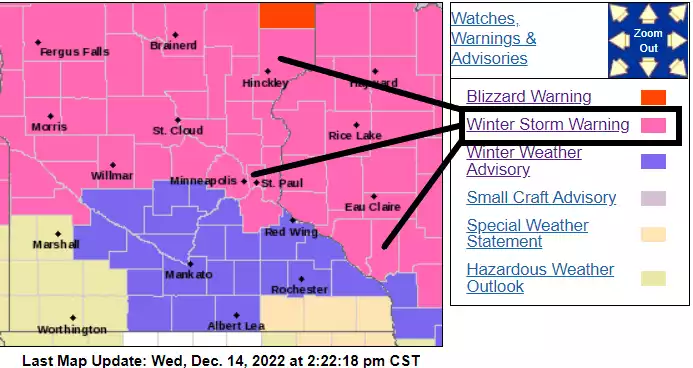
Winter storm warnings and advisories
Twin Cities National Weather Service office

Updated: 6:02 p.m.

Forecast models are still on track to deliver expanding snowfall coverage across Minnesota overnight and Thursday. The primary forecast details in the post below are still on track.

Expect rush hours and travel conditions Thursday to be challenging across most of Minnesota.

Here are some updated snowfall totals as of early evening Wednesday.

  • Sea Gull Lake [Cook Co, MN] 6.3”

  • 1 NE Wadena [Wadena Co, MN] 7.20”

  • Deer Creek [Otter Tail Co, MN 8.40”

  • Lester Park (east Duluth) 10.5”

  • 3 NNE Rice Lake [St. Louis Co, MN] 12.0”

  • 1 S Finland [Lake Co, MN] 12”

****

Create a More Connected Minnesota

MPR News is your trusted resource for the news you need. With your support, MPR News brings accessible, courageous journalism and authentic conversation to everyone - free of paywalls and barriers. Your gift makes a difference.

Get ready for round 2, Minnesota.

Winter storm warnings now include the greater Twin Cities area through Thursday.

Including the cities of Minneapolis, Blaine, St Paul, and Hastings

147 PM CST Wed Dec 14 2022

...WINTER STORM WARNING IN EFFECT FROM MIDNIGHT TONIGHT TO 6 PM CST THURSDAY...

* WHAT...Heavy snow expected. Precipitation may start as rain later this evening, but will quickly change to snow overnight. Total snow accumulations of 4 to 7 inches.

* WHERE...Hennepin, Anoka, Ramsey and Dakota Counties.

* WHEN...From midnight tonight to 6 PM CST Thursday. * IMPACTS...Plan on slippery road conditions. The hazardous

Our massive winter storm is still swirling around the Upper Midwest. The precipitation plume with this system wraps around the low-pressure center from Denver through the Dakotas, northern Minnesota, and Wisconsin all the way south to the Gulf of Mexico Wednesday. The precipitation plume stretches about 2,500 miles!

Massive low pressure system
A massive low-pressure system is creating a 2,500-mile-long precipitation shield.
National Oceanic and Atmospheric Administration radar, via MPR News

Snowfall totals so far

Snow is piling up Wednesday along the North Shore. Intense snowfall plumes are dumping snowfall rates of 1 to as high as 3 inches per hour.

And check out this great little thunder snow burst from Duluth:

As of this post over a foot of snow has already fallen 7 miles northwest of Two Harbors.

Snowfall totals are climbing fast along the North Shore. Here are some more select snowfall totals as of Wednesday afternoon, in inches:

  • Near Two Harbors, 12.5

  • Grand Forks, N.D., area 12

  • Duluth, 10.5

  • Finlayson, 10

  • Perham, 9.5

  • Brimson, 8.5

  • Brainerd, 8

  • Moose Lake, 8

  • St. Cloud, 5-6

  • Buffalo, 4

  • St Michael, 3

  • Hopkins, 2.5

  • Ham Lake, 2

Next wave overnight

The low-pressure system will slide east into Wisconsin overnight then still Thursday. Another moisture plume will wrap around the system, expanding snowfall coverage across most of Minnesota overnight into Thursday.

The National Oceanic and Atmospheric Administration’s NAM 3 km model captures the spinning low and snow plumes wrapping around the system between 6 p.m. Wednesday and 6 a.m. Friday:

NOAA NAM 3 km model
NOAA NAM 3 km model between 6 p.m. Wednesday and 6 a.m. Friday.
NOAA, via Tropical Tidbits

Significant snowfall totals still ahead

The stalling storm and long snowfall duration will produce hefty snowfall totals across most of Minnesota by Friday. The Twin Cities could easily pick up an additional 4 to 8 inches by Friday. A foot may fall across parts of northern Minnesota.

Snowfall projection for Minnesota
NOAA

And the North Shore snowfall totals still have the capacity to produce additional feet of snow. I will not be surprised to see total snowfall over 3 feet along parts of the North Shore from this storm.

NOAA NAM 3 km model snowfall output
NOAA NAM 3 km model snowfall output through 6 p.m. Friday
NOAA, via Pivotal Weather

Keep track of the latest and frequently changing winter warnings and advisories with these National Weather Service office websites: