Updraft® - Minnesota Weather News

Heavy snow by Thursday across southern MN; Twin Cities may see 3-6 inches

Heaviest likely across southeastern Minnesota

NOAA NAM 3 km model
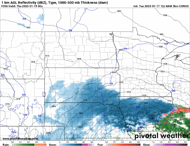
NOAA NAM 3 km model between 6 p.m. Wednesday and 6 p.m. Thursday
National Oceanic and Atmospheric Administration, via Pivotal Weather

Here comes our next winter storm, Minnesota. This one will focus most heavily on southeastern Minnesota Wednesday night and Thursday.

Winter storm watches are up for areas just south and east of the greater Twin Cities metro area for Wednesday night and Thursday. Thursday morning’s Twin Cities rush hour looks difficult.

Winter storm watch
Winter storm watch
Twin Cities National Weather Service office

Including the cities of Le Sueur, Faribault, Red Wing, Mankato, Waseca, Owatonna, Fairmont, Blue Earth, and Albert Lea

337 AM CST Tue Jan 17 2023 ...WINTER STORM WATCH IN EFFECT FROM WEDNESDAY EVENING THROUGH THURSDAY AFTERNOON...

* WHAT...Heavy snow possible. Total snow accumulations of 5 to 8 inches possible.

* WHERE... Martin, Faribault, Freeborn, Blue Earth, Waseca, Steele, Le Sueur, Rice, and Goodhue Counties.

* WHEN...From Wednesday evening through Thursday afternoon. * IMPACTS...Plan on slippery road conditions. The hazardous conditions could impact the Thursday morning commute.

Snowfall timing

The National Oceanic and Atmospheric Administration’s NAM 3 km model loop above tracks the snow zone as it spreads from southern Minnesota Wednesday night across the Twin Cities and more of Minnesota and Wisconsin Thursday.

The Twin Cities should be mostly dry during Wednesday evening’s rush hours, but Thursday morning will feature snow and tougher travel. Right now it looks like snow will begin across southern Minnesota between 6 p.m. and 9 p.m. Wednesday night.

Snow looks likely to move north into the Twin Cities area between about 9 p.m. and midnight Wednesday. The heaviest snow will fall overnight into Thursday morning.

Snowfall totals

This is a potent system with the capability to produce 5 to 10 inches across southern Minnesota into Wisconsin.

Here’s NOAA’s North American Mesoscale Forecast System 3 km model snowfall output:

NOAA NAM snowfall
NOAA NAM model snowfall output
NOAA, via Pivotal Weather

If the current storm track holds up, the Twin Cities will ride the northern edge of the heavier snowfall zone. That will produce a bigger range across the Twin Cities with the heaviest snow in the southeast metro and lesser totals northwest.

Right now, most forecast models favor a range of as little as 2 inches in the far northwest of Twin Cities region, to as much as 6 or 7 inches in the southeast around Dakota County. Most of the Twin Cities would end up in a range of 3 to 6 inches if current forecast tracks hold up.

Snowfall projection
Snowfall projection for the greater Twin Cities area
Twin Cities National Weather Service office

Be ready for another snowy commute Thursday!

Dear reader,

Your voice matters. And we want to hear it.

Will you help shape the future of Minnesota Public Radio by taking our short Listener Survey?

It only takes a few minutes, and your input helps us serve you better—whether it’s news, culture, or the conversations that matter most to Minnesotans.

Volume Button
Volume
Now Listening To Livestream
MPR News logo
On Air
1A: Friday Domestic News Roundup