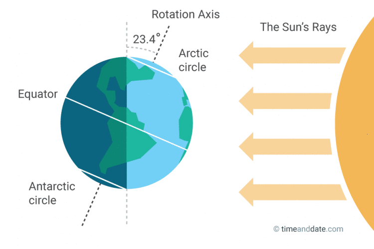
Summer solstice occurs at 9:57 a.m. Wednesday
Warmer and more humid weather ahead for the first days of astronomical summer.

Here come the first days of astronomical summer, Minnesota.
The summer solstice occurs at 9:57 a.m. Wednesday. That moment marks the point at which the sun’s apparent path in the sky reaches its furthest northward point of the year relative to the equator.
Minnesota enjoys the longest daylight of the year Wednesday. We’ll bask in 15 hours and 36 minutes of daylight Wednesday in the Twin Cities.

We’re also moving into the two warmest months of the year on average in Minnesota. The average high temperature in the Twin Cities reached 80 degrees Saturday. The average high in the Twin Cities stays at or above 80 degrees through August 24. It peaks at 84 degrees between July 8 and July 24.
Grow the Future of Public Media
MPR News is supported by Members. Gifts from individuals power everything you find here. Make a gift of any amount today to become a Member!
Spotty rainfall over the weekend
A weak low-pressure system spun through Minnesota on Father’s Day.
It produced spotty rainfall. But some areas did pick up meaningful rains, especially in western and southern Minnesota. Here are some select rainfall totals from Saturday into early Sunday.
MSP Airport .01”
Mankato .31”
New Ulm .41”
Worthington .53”
Crookston .54”
Hutchinson .62”
Glencoe .81”
Montevideo .91”
Kiester 1” to 2” locally
Warm Juneteenth
Juneteenth and the week ahead will feel like summer. Highs will be around 90 degrees much of this week for the Twin Cities and much of southern and western Minnesota.

Many areas need rain but this week looks mostly dry. The next rain chances arrive late this week into next weekend.
Our southerly wind flow this week will push most of the wildfire smoke away from Minnesota to the north. Wind may shift by Friday, and it’s possible smoke from Ontario wildfires could blow south into Minnesota late next week.
Stay tuned.