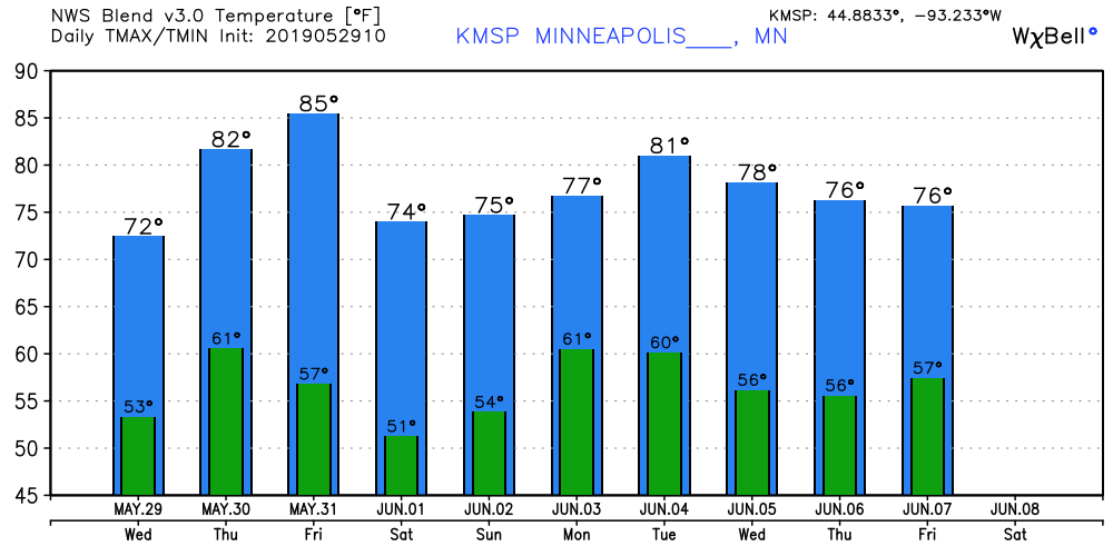
The southern two-thirds of Minnesota, plus much of western Wisconsin, will see Friday highs well into the 80s. A few spots could creep above 90, even in the Twin Cities metro area. Roughly the northern third of Minnesota will top out in the 70s, with some 60s in parts of the northeast.
A cold front sags slowly through Minnesota Friday afternoon and Friday night, triggering some scattered showers and thunderstorms. Our rain chance in the Twin Cities will probably hold off until Friday evening. That rain chance will continue into early Saturday.
On Monday, the U.S. tied its current record of 11 consecutive days with at least eight tornadoes confirmed on each of those days, said Patrick Marsh, warning coordination meteorologist for the federal Storm Prediction Center.
Spring planting is about two weeks behind. Farmers will soon need to decide whether they'll try to plant late, and run the risk of losing their crops to an early frost, or if they'll work up to an insurance payment deadline and take a loss on the seeds they're not able to get into the ground.
The upper air maps finally suggest a ridge of high pressure pumping summerlike air into the Upper Midwest the second week of June. Highs near 90 in the next two weeks?
How wet has it been? The 1.83 inches of rain at Minneapolis-St. Paul International Airport on Memorial Day brought our 2019 precipitation total (rain plus the water content of snow) to 15.61 inches. That’s the third highest precipitation total from January 1 through May 27 in Twin Cities weather records: It was a soggy Memorial…
At least half a dozen communities from eastern Indiana through central Ohio suffered damage, according to the National Weather Service, though authorities working through the night had reported no fatalities as of early Tuesday.
When it comes to staying informed in Minnesota, our newsletters overdeliver. Sign-up now for headlines, breaking news, hometown stories, weather and much more. Delivered weekday mornings.