Updraft® - Minnesota Weather News

Updraft® is your source for Minnesota forecasts and insights from our expert meteorologists Ben Cathey, Sven Sundgaard and Mandy Thalhuber.

MPR News brings you the latest weather outlook, across all of Minnesota, so you can be better prepared for your day.

Sign up for daily Minnesota weather forecasts from us below.
Cold Saturday into early Sunday; temps rebound Sunday afternoon
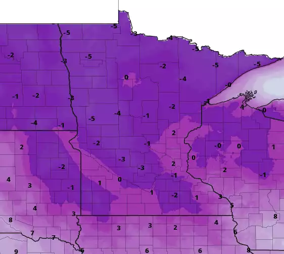
Today will be the coldest day of the weekend, then Sunday highs will be much closer to normal. We have details on that, plus a look at who could see some snow on Sunday. We also take a look at November weather stats for the Twin Cities.
Arctic cold Saturday; temps rebound Sunday afternoon
Arctic cold will stay with us Saturday, then temps rebound Sunday afternoon. A wind chill advisory continues Saturday morning in northwestern Minnesota.
Friday night's windy with some snow, plunging temps; very cold Saturday
Gusty winds and periods of snow will combine with plunging temps to create low visibilities and some slippery spots on streets and highways Friday evening. It’ll feel like January on Saturday, then temps recover a bit Sunday afternoon.
Temperature swings, wind, snow; very cold Saturday, milder Sunday
Temperatures will range from near 40 in southeastern Minnesota to the teens in northwestern Minnesota Friday. Snow showers develop midday in the northwest and spread east and southeast. Winds increase Friday night with 35 to 45 mph gusts. Saturday will be much colder.
Mild southeast, snow develops northwest; windy late
Highs will be 40 in southeast Minnesota while temperatures will be only in the teens in the northwest. A winter weather advisory goes into effect midday into Friday night in northern Minnesota as snow and wind develop. It’ll be windy and colder for everyone Friday night into Saturday.
Friday temps milder, snow late; winter weather advisory northwest
Expect temperatures in the 20s overnight. Friday brings highs near 40 in the southeast with teens in the northwest. Snow showers develop midday in northwestern Minnesota and spread south and east Friday into Saturday.
Weekend weather: Cold, breezy Saturday; temps recover a bit on Sunday
You’ll need your warmest winter clothes on Saturday, then temps recover a bit on Sunday and winds will decrease. We have your weekend forecast details, plus a look at who will see the most snow on Friday.
Milder Thursday, snow chance Friday; cold, windy Saturday
Look for a milder couple of days as temperatures warm to near freezing in southern Minnesota Thursday afternoon and closer to 40 Friday. Temperatures will be mainly in the 20s in northern Minnesota. Winds pick up again Friday night as snow and cold return.
Cold start but warmer afternoon Thursday; more snow late Friday
It’s a cold start with single digits and teens early Thursday morning and subzero wind chills but we’ll rebound quickly. Highs will be in the 30s south and 20s north by afternoon. It’ll be breezy still but from the southeast at 10-20 mph. More snow is on the way for mainly northern and central Minnesota late Friday.
Milder Thursday afternoon and Friday, then much colder
Cold winds on Wednesday will give way to milder temperatures on Thursday and especially Friday. Periods of light snow are likely for Friday and Friday night as much colder air approaches for the weekend.